There is crude oil on Mars !
Within the collapse alcove of the giant Hebes Mensa salt dome on Mars, there is a feature called the "Oil Spill" (Adams et al., 2009). According to these researchers the fluid consists of liquid brines that have been coloured black by dark dust particles. However, - this cannot be true.
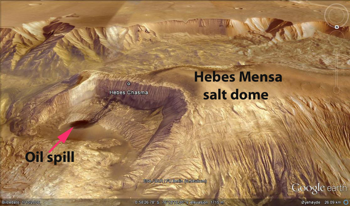
Figure 1. This is what the "Oil spill" feature looks like on Google Mars.
It is located on the eastern collapsed side of the Hebes Mensa salt dome.
To me, this explanation is physically not possible. According to own earth-bound research, over the past 5 years, the most probable explanation is that the liquid substance consists of crude oil.

Figure 2. Here is a close-up of the Oil Spill inside Hebes Chasma, at the eastern limb of Hebes Mensa. The oil has issued out of the collapsed wall of the salt dome at elevation +443 m. It has run down the slope inside Hebes Chasma and pooled on the plain below, at an elevation of -1457 m. The top of the exposed salt dome is at 2807 m, so these dimensions are great. Although the size of the oil pool is large, it would probably not be called "commercial" if it was found on Earth. In Azerbaijan and also in the Gulf of Mexico, there are natural oil spills (called 'seeps'), that are equivalent the one on Mars.
Earth analogue features
There are similar crude oil seeps on Earth. Close to the McKittrick oil field in California, there is a well-known natural oil spill shown in Figures 3 and 4. They occur within walking distance of access roads.

Figure 3. This is my footprint in a natural oil spill near the Mckittrick oil field in California (2006).

Figure 4. The environs of McKittrick oil field, California, with natural "Brea" (asphalt) seeping out of the ground. Although the spills here do not show "braided flow" patterns, they are equivalent to the Oil Spill on Mars (from Google Earth).

Figure 5. Here is a braided aqueous flow, from a brine sping adjacent to a salt lake in Kasakstan (from Google Earth).

The current theory
The currently published model for how the "Oil Spill" feature on Mars formed is briefly reviewed and commented below:Adams et al. (2009) suggested that the giant Hebes Mensa salt dome structure is an "arching, emergent salt diapir". They have no good explanation on how it may have formed, nor how it links to the other features associated with it. For example, their explanation for the deep troughs surrounding the arch is: "A collapse of megaregolith by drainage of ~100.000 cubic kilometers of brines and entrained particles that drained into a regional (underground) aquifer." In other words, they want us to believe that parts of the surface of Mars surrounding Hebes Mensa (arch) dissappeared into a hole in the ground, via a dramatic washing away by water mixed with salt (brine).
Several questions to this model occur: Where did the brines come from? Where is the hole in the ground into which the water and particles dissappeared? What type of aquifer can this be, located under the Hebes Mensa and Hebes Chasma features?
Finally, we shall dwell with Adams et al's (2009) description and explanation of the "Oil Spill" feature itself. These are the exact words used on pages 692-693: "Dark fluid flows also occur on the sides of Hebes Mensa, the base of the chasma walls adjacent to the pits and troughs, and along fissures on the chasma floor. The conspicuous braided flow from the northeast alcove of Hebes Mensa here dubbed "Oil Spill" (Fig. 4C), was interpreted by Ori et al. (2005) as a low viscosity lava flow; however, a Mars Reconnaissance Orbiter Camera image shows that the braided channels are smooth ridges and that the terminal deposit has a feather edge that grades into the surrounding, paler surface. We interpret the Oil Spill as particulates (basaltic tephra?) derived from LHF [Lower Hebes Formation] and entrained in aqueous springs along fracture zones. Dark material may have accumulated in the Oil Spill channels as water evaporated."
Again, pertinent questions beg for good answers: How can an "aqueous spring" both come to surface and run down a slope making braided flow patterns? This is not possible, as you either have a spring from which the "water" emits and then runs down the slope. But, it would not be possible to have an "aqueous flow" of any kind on the surface of Mars - as the water immediately evaporates in contact with the atmosphere, even if it is salt-saturated water.
Therefore, the conspicuous braided aqueous flow on Mars is neither formed by water nor by lava. The only option is that it formed by crude oil emitting from the interior central conduits of Hebes Mensa, the collapsed giant salt dome, and flowing down the side, onto the Hebes Chasma floor.
There is one other very important observation made by Adams et al. (2009). In their Figure 2 C caption they state: "Botryoidal structures on top of Hebes Mensa resulting from fluid escape or diapirism." This means that salt-laden fluids have percolated inside the Hebes Mensa salt dome, in complete agreement with our own model of how salt domes are formed by rising brines and other material from the deep sub-surface (Hovland et al., 2011). Salt on two planets.
In the following, I will build up the model which not only explains how oil can form on Mars, but also how Hebes Mensa, and not least, the impressive Hebes Chasma may have formed, by processes that we also have on Earth.
The basis of my model
The explanation model is based on several features and processes that also occur on Earth, although some of them are still not fully understood. The model is based on combining knowledge of- Hydrothermal processes (underground high-temperature water-associated processes), with those of
- Serpentinization (a very important geological process on Earth and Mars),
- Salt dome formation,
- Mud volcanism,
- Supercritical water (SCRIW) transport under ground, and
- Abiotic oil formation (Fisher-Tropsh, etc).
1. Hydrothermal processes
Hydrothermal processes occur as a consequence of the great heat contrast between the temperature in the upper mantle and the bottom of the ocean, which is the top of the oceanic crust. The temperature gradient between these two locations can be as high as 1200 degrees C. At plate boundaries and cracks in the oceanic crust, this leads to the circulation of seawater through the curst. Thus, seawater is gradually (in some places) and rapidly (in other places) heated to extreme values. This leads to a host of different extremely important processes inside the oceanic crust. These are the hydrothermal processes, which not only affect life, minerals, and alteration of the rocks, but also lead to the precipitation of salts, formation of serpentinite, and abiotic hydrocarbons (oil or petroleum).Hydrothermal processes
2. Serpentinization
Serpentinization is the process whereby water reacts with rocks in the upper mantle (peridotite) to form serpentinite. The water reacts strongly with the olivine (magnesium silicate) in the peridotite, and causes additional warming (exothermal heat), volume expansion (because of the added water to the new rock (serpentinite), and to the release of excess free hydrogen (H2).Take a look at the results of serpentinization in the deep ocean:
"Lost City" serpentinization in action...
During the
process of serpentinization, the mineral Olivine contained in basalt, is
transformed into Serpentinite and Magnetite, and producing hydrogen as a
by-product (Charlou et al., 1998):
6(((Mg 1.5)Fe
0.5)SiO4)+7H2O à 3(Mg3Si3O5(OH4)) + Fe3O4 +
H2
OLIVINE +
WATER à
SERPENTINE + MAGNETITE + HYDROGEN
This process is important for three main reasons:
1)
it
produces H2
2)
it
uses up fresh water and produces salt
3)
it
causes volume expansion (about 40%)
4)
it
leads on to methane production :
Abiogenic
methane can be produced by the serpentinization process in the crust, via the
Fischer-Tropsch reaction (Szatmari, 1989):
H2
+ CO2 à CH4
+ H2O
According to Keith et al. (2008), there is a whole sheath of serpentinite underneath most of planet Earth (and also parts of Mars). They call this sheath for the "Serpentosphere":
The Serpentosphere consists of an
earth-wide nearly continuous layer (or spherical shell) of rock dominated by
serpentinite. The Serpentosphere is typically about
two kilometers thick beneath ocean basins where it is mainly composed of
lizardite. Beneath continents, the Serpentosphere is mainly composed of
antigorite (alpine peridotite/serpentinite) and may be several kilometers
thick. The base of the Serpentosphere coincides with the gravity and
high-velocity seismically defined transition beneath both continents and ocean
basins commonly referred to as the Moho.
Beneath ocean basins and adjacent to spreading centers, oceanic Serpentosphere is continuously generated by the interactions of deep circulating marine composition water – partly in super-critical state –with harzburgitic peridotite in the process referred to as serpentinization. Conversion of the harzburgite to lizarditic serpentine under supercritical condition is texturally preservative and probably induces about 40% volume expansion. The volume expansion provides an excellent mechanism to expel and propel fluid products – including hydrocarbons – from the area of serpentinization to seep sites at the crust hydrosphere/atmosphere interface.
A downward diffusing, super-critical serpentinization front is present beneath every ocean basin and is more active where it originally formed near oceanic ridge thermal anomalies. When ocean Serpentosphere is subducted beneath continental or oceanic crust areas, it converts to antigorite-dominated serpentinite rock (generally coincident with greenschist facies metamorphism). During flat subduction, the relatively low density antigorite ‘floats’ and is underplated to the base of the continental crust at the Moho geophysical interface.
In effect, both oceanic and continental Serpentospheres reflect a deep ‘weathering’ process that consists of the interaction of deep crustal and oceanic, water-dominated fluids with the upper portion of a mainly harzburgitic peridotite at the top of the earth’s lithospheric mantle. The Serpentosphere may be viewed as a thin membrane that separates water-absent, life-free abiogenetic processes in the mantle from water-present, life-related processes above the Serpentosphere in the oceanic crust.

Figure 7. This illustration, by Stan Keith and Monte Swan (2004) shows the whole concept of why serpentinization is so important for life on Earth. The process has also been active on Mars, but has probably not lead to life there (because of the difficult atmospheric situation, where liquid water is not stable).
The Serpentosphere has enormous and novel implications for four major geologic problems that are of current interest to the geologic and social community:
1) the driving mechanism for plate tectonics,
2) the origin of life,
3) the origin of hydrocarbons, and
4)contributions to global climate.
Because the Serpentosphere has been continuously generated since the beginning of geologic time it must be considered as one of the fundamental entities of our water-surfaced planet – the only water-planet we know of ...
Serpentinization on Mars
Salt from serpentinization
3. Salt dome formation (on Earth and Mars)
Several pre-requisites must be fulfilled
for the formation of salt chimneys (domes) by hydrothermal processes. These are briefly reviewed below.
Sub-surface accumulation of salt
According to our model, salts may accumulate in
sub-surface fracture systems and porous rocks by the precipitation from
circulating seawater that has attained super-critical conditions. Boiling
may also lead to increased salt concentrations of brines. In both instances,
salt is accumulating in the porous rocks, and the ‘fresh water’ is led out of
the hydrothermal system due to differences in densities.
When the hydrothermal system is sufficiently cooled down (below the
critical point of water), the hot water will transport the accumulated
salts upwards as a brine and salt slurry, and subsequently (upon further
cooling), build up chimneys of the least soluble components (e.g. anhydrite,
silica and sulphides) followed by the precipitation of halite (NaCl). KCl and MgSO4
are more soluble than NaCl in hot water and the “refining process” commences
with the salts KCl and MgCl2 being transported further. The latter salts may
subsequently vent out on the surface (like occurs in Black Mountain
hot springs in Danakil, Ethiopia) or form layers of high density brines on the seafloor as
observed in Discovery Basin of the Mediterranean Sea
(Winckler et al., 1997). It is suggested that the Dead Sea evaporites
(including the Lisan structure and the Sedom ‘diapir’) and the northern Red
Sea elongated salt domes are
also the results of such saline hydrothermal conduits.
Earth analogue features
A Google Earth image of ‘Upheaval Dome’, in the Paradox Basin, Utah, USA, appears in Fig. 8. This erosive ‘Bulls eye’ feature contains anhydrite in its centre, and is suggested to represent the remains of an ancient salt dome (Mattox, 1968). Other features are also pertinent: 1) The ring-shaped rocks surrounding the anhydrite remains, in our model these represent the enclosing sediments that have surrounded the salt dome, during syn-sedimentary growth. 2) The canyon opening at the far side, which suggests that large amounts of fluids have escaped, even though the catchment area of the structure is very small. We suggest that brines have continued seeping to surface, and filled the circular structure even after it was exposed, and that saline water has eroded the canyon opening.
 Fig. 8. This "Bullseye" structure is found in Paradox Basin, Utah, and is called "Upheaval Dome". See text for further details. This is actually a miniature analogue of how Hebes Mensa on Mars may have formed. Image from Google Earth.
 Fig. 9. Here is another example of a collapsed (dissolved) salt dome on Earth. This is the La Popa salt dome in Mexico. Image from Google Earth. Whereas most of the Hebes Mensa salt dome on Mars is still intact, the exposed salt domes on Earth have only a short life, as Earth's atmosphere contains water vapor and liquid water, that dissolves the exposed salt. This is not the case on Mars, and the exposed salt domes can survive for millions of years. Perhaps we should rather study salt domes on Mars, rather than on Earth?
A Google Earth image of ‘Upheaval Dome’, in the Paradox Basin, Utah, USA, appears in Fig. 8. This erosive ‘Bulls eye’ feature contains anhydrite in its centre, and is suggested to represent the remains of an ancient salt dome (Mattox, 1968). Other features are also pertinent: 1) The ring-shaped rocks surrounding the anhydrite remains, in our model these represent the enclosing sediments that have surrounded the salt dome, during syn-sedimentary growth. 2) The canyon opening at the far side, which suggests that large amounts of fluids have escaped, even though the catchment area of the structure is very small. We suggest that brines have continued seeping to surface, and filled the circular structure even after it was exposed, and that saline water has eroded the canyon opening.


Thermal conductivity of rock salt
Although
the thermal conductivity of rock salt is 3-5 times higher than shale (the
dominant clastic sediment type in sedimentary basins), a relatively rapid
internal fluid transport will prevent the fluids from cooling excessively. Such
diffusive and focused transport favours gradual internal re-crystallisation of
salts when the brines migrate inside the chimney, and is important for the
‘refining’ of the salt. This continuous dissolution – precipitation process (in
‘active’ salt chimneys) can also be inferred from the observations in the salt
mines (Loof , 1999;
Kupfer et al., 1998; Hoy et al., 1962).
Internal and external pressure forces
Internal and external pressure forces
The
internal pressure of a developing salt chimney is maintained by gas and water
vapour. A pressure build-up due to salt precipitation and clogging of the
conduit, will cause the propagation of cracks upwards. The height of a
developing salt chimney is determined by the hydrostatic pressure difference
between seawater/sediments on the outside and the internal pressure in the
brine/vapour/gas/salt. This pressure difference controls the growth of the salt
chimney together with the supply of salt. The diameter of the salt chimney is
also determined by these parameters at any given time. If the salt chimney
grows in equilibrium with the surrounding sedimentation rate, the internal and
external pressure forces are in equilibrium, and the salt stock tends to grow
with a constant diameter. If the growth of the salt chimney is faster than the
sedimentation rate and its apex approaches the seafloor, the diameter of its
apex tends to expand (i.e. attain a ‘mushroom’ shape).
4. Mud Volcanism

Figure 10. A so-called 'gryphon' on the large Dashgil mud volcano south of Baku (from Hovland et al., 1997). Liquid mud, gas, and oil is tranported naturally from an unknown depth below ground to the surface. The gryphons are associated with pure (fresh) water, as salty water (brine) does not transport mud to surface
The next image, is a conceptual presentation of the Dashgil mud volcano, where the above photo has been taken.

Figure 11. A conceptual block diagram of Dashgil mud volcano. The above photo was taken at 'A', i.e., at the gryphons, caused by fresh water (condensation water) flow to surface. 'B' shows a 'salse', which is a brine pool, caused by salt water flow to surface (blue arrows). 'C' is a line of sinter cones, demonstrating that there has been fire on the mud volcano at one instance (forming burned clay - sinter). 'D' is a pool of crude oil, showing that oil is also transported within the mud volcano, but is diverted outside the main conduit some depth below ground.
Mud volcanoes in the Gulf of mexico
There are even mud volcanoes on top of the fishing banks and natural sanctuaries "East and West Flower Garden Banks" in the northern Gulf of Mexico. Why are they there? To us, the reason is simple: These banks are formed on top of deep-rooted salt domes, that tap hydrothermal fluids at depth. Some of the surplus fluids rise through the internal central conduits of the salt domes and issue through their tops. This is where the mud volcanoes and underwater brine lakes occur. This is also where small amounts of hydrocarbons issue to the water column and fertilizes the local biosphere (i.e., the banks).
Look for the supporting evidence here:
Asphalt volcanoes in Gulf of Mexico (The Chapopote case study)
Asphalt volcanoes associated with a huge, deep-rooted salt dome was first published by MacDonald et al., in 2004, in Science.

Figure 12. A conceptual sketch explaining how the asphalt formed at over 3000 m water depth in the southern Gulf of Mexico. 1) the > 5 km deep salt dome, through which supercritical water transports dissolved minerals, including oil and bitumen to surface, through the interior, central conduit, 2).
Our theory is that the Chapopote and other similar asphalt volcanoes and salt domes in the southern Gulf of Mexico formed as a consequence of deep hydrothermal processes. Thus, at over 8 km depth below the sea surface, both salt and hydrocarbons are formed by hydrothermal circulation of seawater. The supercritical water transports the liquid solutes and slurry upwards inside the central conduit, and the hydrocarbons eventually condense to liquid and the remaining heavy bitumen solidifies as a volcanic deposit on the seafloor, after cooling down during deposition.
The theory is provided here: http://www.marum.de/Binaries/Binary_32068/Hovland_2005.pdf
In effect, we conclude that the Mexican "Chapopote Asphalt Volcano", sitting at over 3000 m water depth in the southern Gulf of Mexico is partly an analogue to the Hebes Mensa, giant salt structure on Mars. Because the Hebes Mensa structure is exposed on the surface of a very dry planet, which is "salt-friendly", and because parts of the salt dome has collapsed, the interior asphalt, or crude oil, has spilled onto the surrounding plain. See also the video from Chapopote, Here.
Mud volcanoes on Mars
Also on Mars there is growing evidence of extensive formation of mud volcanoes.
A deep origin of mud volcanism?
Although mud volcanoes have been strudied for over a century (research started in Azerbaijan, on Trinidad, and Iran), there is still no good explanation on what drives them. Our own idea, is that they somehow represent the surface manifestation of buried hydrothermal systems, located at the boundary between the crust and the bottom of deep sedimentary basins. Water evidently has a central role in the driving mechanism. In our explanation model, water becomes superctical and causes hydrothermal alteration to the sediments, thus forming the liquid fine (clay gel) particles that well up. An early version of our model was published in 2006, in the paper: "Deep-rooted piercement structures...", from which the following figure is copied.

Figure 13. The concept of super-critical water driven mud volcanoes. The left diagram is a cross-section through a deep-rooted mud volcano. The total depth is >10km. At surface is the characteristic cone of the mud volcano. The temperature of the rising mud, liquids, and gases is ambient, as the substances rise slowly through the central conduit and has time to equalized the temperature. "IR" is an Intermediate Reservoir, where oil and water condenses. This is where liquid oil, freshwater, and brines have been refined from the rising warm fluids. The star-shaped form at the base of the column (beneath the two arrows) represents the reaction zone, where supercritical water is actively producing mud gel, and hydrothermal oil. The two other columns in the diagram represent pressure conditions (central column), with the hydrostatic pressure gradient, actual pressure grandient, and lithospheric pressure gradient illustrated. The column to the right shows the inferred temperatures with depth, inside the central conduit of the mud volcano. "LH" represents the 'latent heat' zone, "RB" is the retrograde boiling zone, and SCRIW is the supercritical water zone. See (Hovland et al., 2006): Here.
5. Supercritical water
One of the strangest phases of water is the supercritical phase (SCRIW). Whereas pure water (H2O) is a liquid at room temperature, it turns into a gas (vapor) upon boiling (at temperatures > 100 degrees C, at sea-level), and turns into a solid substance at temperatures < 0 degrees C. However, if you contain the water inside a pressure cooker or heat it at great depth, subsurface, it can no longer boil because of the high confinement pressure. It then suddenly enters into a mixture of liquid water and vapor, and attains a density of about 0.3 g/cu cm. This water phase have dramatically altered properties compared to the pure liquid we know of.
Thus, when water
is heated under high pressure (> 220 bar) by for example an intrusive basalt
or adjacent to a magma chamber, it cannot boil (develop into vapor), as the pressure is too high.
-
boiling
stops at 374.15 oC, at a highest pressure of 221.2 bar (for pure water without salts)
-
it
has a bulk density of 0.322 g/cm3, and a specific volume of 0.31
-
it loses
its dipolar character (is no longer dipolar)
-
pH
varies: The pH range 8 – 12.7 is common with H2 and Magnetite at Eh
of –0.4 to --0.8 V (at lower pH and Eh hydrogen is in a stable dissolved mode).
There are numerous geological implications associated with SCRIW. For example it can transport dissolved oil for long distances under-ground. The oil will be deposited (as a condensate or precipitated liquid) when the SCRIW rises towards surface (is de-pressurized) or when it cools down to below about 400 oC.
SCRIW also represents the ultimate temperature and pressure barrier for normal life forms. This is because SCRIW is so "aggressive" that it dissolves all organic material. However, it does not dissolve certain salts - therefore the SCRIW phase of water is an effective salt producer from seawater.
6. Abiotic oil formation
The origin of oil has been discussed hotly for over 100 years. In Russia it has been more common to accept the concept that oil has a deep origin within our earth, and that it has little to do with fossilized life forms. However, it was not before Dr Peter Szatmari, a geologist in Petrobras (Brazil), in the 1980's found a strong corellation between concentrations of trace metals in crude oils with those of serpentinite rock in nearby basement rocks, that the link became plausible also for western researchers. Because the pressure to discuss this controversial theme (origin of oil) was rising, the American Association for Petroleum Geologists (AAPG) finally arranged a one-day research conference in Calgary, Canada, in 2005 http://www.searchanddiscovery.com/documents/abstracts/2005research_calgary/index.htm
See also Szatmari et al., 2011
At the end of the day, Dr Barry Katz, who chaired the research conference, made the following conclusion: "Yes, we conclude that there are abiotic hydrocarbons on Earth. However, they are not of commercial value." For further facts over this theme, which also includes hydrocarbons on Titan, please visit the excellent site: living-petrol
7. Conclusions and consequences of oil on Mars
Because oil is an "organic material" (in science, it belongs to 'organic chemistry'), it should be able to stimulate one or several of the instruments on 'Opportunity' and 'Curiosity', now roaming around on Mars.
However, it is not likely that either of the rovers will pick up any evidence of oil on Mars, as they are currently located in places without seeps to the surface. Next time a sonde is sent to Mars, it could be sent either to one of the known mud volcanoes, or to places like Hebes Mensa and Acidalia Mensa. Here it should be able to find fluids (most likely brines + a little oil, or light hydrocarbons, including methane) that originate from the interior of Mars.
The sad story, for many (Nasa included), is that the likelyhood of finding life on Mars is really meagre. Because pure water is not stable (i.e., it evaporates, or boils off) on the surface of Mars, normal life cannot develop there. However, there is a small chance that there could possibly be some extremophiles, that live inside brines. Brines are solutes, containing water, but with very high concentrations of salts. Extremophiles are micro-organisms that live 'on the edge'. They are found on Earth in brine lakes and in hot vents and are catalogued as either bacteria or archaea.
8. References
Adams, J.B., Gillespie, A.R., Jackson, M.P.A., Montgomery, D.R., Dooley, T.P., Combe, J.-P., Schreiber, B.C., 2009. Salt tectonics and collapse of Hebes Chasma, Valles Marineris, Mars. Geology, 37 (8), 691-694Adams et al. (2009)
Keith, S., Swan, M.M., Hovland, M., Rueslaatten, H., Johnsen, H.K., 2008. The Serpentosphere. Arizona Geological Meeting, March, 2008.
Szatmari, P., 1989. Petroleum formation by Fischer-Tropsch synsthesis in plate tectonics. AAPG Bull., 73, 989-998.